About This Drill
AP World History Unit 8 Drill 24 is a Multiple Choice practice drill covering Unit 8: Cold War and Decolonization. It contains 5 original questions created by Brian Stewart, a Barron's test prep author with over 20 years of tutoring experience.
This drill uses a world map from 1962 to explore the Cold War alliance structure and its relationship to decolonization. Study the map carefully, paying close attention to the legend and the shading of specific regions, then answer all five questions.
Passage
Figure 1. Cold War Alliance Blocs, 1962
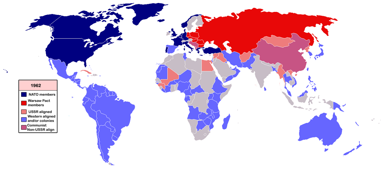
Legend: Dark Blue = NATO members. Red = Warsaw Pact members. Pink = USSR-aligned. Light Blue = Western-aligned and/or colonies. Purple/Mauve = Communist, Non-USSR aligned. Gray = Neutral/Unaffiliated. Map dated 1962.
Questions & Explanations
Question 1. Based on Figure 1, which of the following best describes the global distribution of Cold War alliances in 1962?
- A) The Soviet bloc controlled the majority of the world's territory and population, giving it a decisive strategic advantage over the Western alliance
- B) Most nations in Asia and Africa had achieved genuine independence by 1962 and were evenly divided between the NATO and Warsaw Pact alliance systems
- C) Much of the developing world, particularly Africa, Latin America, and parts of Asia, was shaded as Western-aligned or colonial in 1962, reflecting that formal decolonization was still incomplete and that newly independent states often remained within Western economic and political orbits ✓
- D) The map shows that China and the USSR were formal military allies in 1962, with Chinese forces fighting alongside Warsaw Pact troops in Europe and Korea under a single unified communist command directed from Moscow, with the Warsaw Pact functioning as a single worldwide military organization.
Explanation: C is correct. The map's extensive light blue shading across Africa, Latin America, and parts of Asia, labeled "Western-aligned and/or colonies", reflects the reality of 1962: many African nations had only recently gained independence (the early 1960s were the great era of African decolonization), and most newly independent states initially remained within Western economic relationships through trade, investment, and institutional ties. The map captures a transitional moment in decolonization. A is wrong, the map clearly shows that NATO and Western-aligned territories (dark blue and light blue combined) cover far more of the world's territory than the red and pink Soviet bloc. B is wrong, the map shows most of Africa and Latin America as Western-aligned or colonial, not evenly divided between the two superpowers. D is wrong, the map specifically shows China in a distinct purple/mauve color labeled "Communist Non-USSR aligned," directly indicating the Sino-Soviet split; China and the USSR were not formal military allies in 1962.
Question 2. Figure 1 shows China in a distinct purple/mauve color labeled "Communist Non-USSR aligned." This reflects which specific historical development?
- A) The Sino-Soviet split, in which ideological disputes and competition for leadership of the communist world caused China and the USSR to become rivals rather than allies by the late 1950s and early 1960s ✓
- B) China's decision to join the Non-Aligned Movement in 1955, formally renouncing military alliance with any superpower in favor of independent foreign policy
- C) The Korean War's end in 1953, after which China withdrew from Soviet-aligned military structures to avoid entanglement in superpower conflicts and publicly declared a policy of formal neutrality in the early years of the postwar settlement
- D) China's successful test of a nuclear weapon in 1964, which gave it independent strategic deterrence and allowed it to leave the Soviet nuclear umbrella
Explanation: A is correct. The Sino-Soviet split developed throughout the late 1950s and became publicly visible by 1960, when the USSR withdrew its technical advisors from China. Disputes centered on ideological differences (Mao criticized Khrushchev's "peaceful coexistence" as revisionism), competition for leadership of the global communist movement, and border disputes along their shared frontier. By 1962, the map's date; China and the Soviet Union were open rivals, which is why the mapmaker correctly distinguished China with a separate color rather than including it in the Soviet red. B is wrong; China was not a founding member of the Non-Aligned Movement and did not formally join it in 1955; that conference (Bandung) included India, Egypt, Yugoslavia, and others as its core. C is wrong, the Korean War's end did not cause China to withdraw from Soviet structures; the alliance remained intact in the mid-1950s. D is wrong; China's nuclear test occurred in October 1964, after this 1962 map; nuclear capability was not the cause of the split shown here.
Question 3. The large areas of light blue ("Western-aligned and/or colonies") visible across Africa and Asia in Figure 1 are best understood in the context of which broader development?
- A) African and Asian nations voluntarily chose Western alignment in 1962 because NATO membership offered military protection against Soviet expansionism and economic development assistance
- B) The Marshall Plan's extension to Africa and Asia, which required recipient nations to formally align with NATO as a condition of receiving American economic aid during the early Cold War years
- C) The United Nations' designation of all former colonial territories as Western-aligned pending their formal admission as member states with independent voting rights
- D) Decolonization was still ongoing in 1962, and many newly independent African and Asian nations maintained economic, military, and institutional ties to their former colonial powers, particularly France and Britain, even after gaining formal political independence ✓
Explanation: D is correct. By 1962, many African and Asian nations had achieved formal political independence, particularly the burst of African independence in 1960 ("Year of Africa," when 17 nations gained independence), but formal independence did not mean economic or institutional independence from former colonial powers. French-speaking African nations maintained the CFA franc, French military bases, and close governmental ties to Paris through the "Françafrique" system. British Commonwealth nations maintained trade preferences and institutional links. The map's "Western-aligned and/or colonies" category captures this reality of neocolonial relationships persisting beyond formal independence. A is wrong; African and Asian nations did not join NATO; the light blue "Western-aligned" category reflects post-colonial economic and institutional ties, not formal military alliance membership. B is wrong, the Marshall Plan was directed at European recovery, not extended to Africa and Asia; and NATO membership was not a condition. C is wrong, the United Nations made no such designation; this is historically false.
Question 4. Cuba appears on Figure 1 as a Soviet-aligned state near Florida. This is significant primarily because it
- A) demonstrated that communist revolutions could succeed in Latin America, encouraging similar movements throughout the continent that the United States was powerless to prevent
- B) placed a Soviet-aligned state ninety miles from the United States mainland, directly triggering the Cuban Missile Crisis of October 1962 when the USSR attempted to station nuclear missiles there ✓
- C) showed that the Monroe Doctrine had been permanently abandoned by the United States, which no longer opposed foreign intervention in the Western Hemisphere
- D) indicated that the Soviet Union had successfully extended the Warsaw Pact to the Americas, creating a formal military alliance with Cuba that required automatic Soviet intervention if Cuba was attacked
Explanation: B is correct. The map is dated 1962, the exact year of the Cuban Missile Crisis (October 1962). Cuba's Soviet alignment, visible on the map, is the geographic context that made the missile crisis so dangerous: a Soviet-aligned state ninety miles from Florida with Soviet nuclear missiles would have placed the US mainland under direct nuclear threat. Kennedy's quarantine of Cuba and the thirteen-day confrontation with Khrushchev brought the world closer to nuclear war than at any other point in the Cold War. The map captures the precise geopolitical situation that produced that crisis. A is wrong, while Cuba did inspire leftist movements in Latin America, the United States was not "powerless"; it actively intervened throughout the region. C is wrong, the United States did not abandon the Monroe Doctrine; Kennedy explicitly invoked it during the Missile Crisis. D is wrong; Cuba was not a member of the Warsaw Pact, which was a European alliance; Cuba had a separate bilateral relationship with the Soviet Union.
Question 5. Which of the following developments after 1962 most changed the alliance structure shown in Figure 1?
- A) The Vietnam War's conclusion in 1975, which caused the United States to withdraw from all Asian military commitments and dissolve its Pacific alliance network
- B) China's admission to the United Nations in 1971, which required China to formally join the Western bloc in exchange for a permanent Security Council seat and diplomatic recognition by the West
- C) The dissolution of the Soviet Union in 1991, which ended the Warsaw Pact, transformed former Soviet republics into independent states, and allowed Eastern European nations to eventually join NATO, redrawing the map's red and dark blue zones ✓
- D) The Non-Aligned Movement's growth in the 1970s, which caused most light blue Western-aligned nations in Africa and Asia to formally switch their alignment to the Soviet bloc
Explanation: C is correct. The dissolution of the Soviet Union in 1991 was the single most transformative event for the map's alliance structure. The Warsaw Pact dissolved, its member states; Poland, Czechoslovakia, Hungary, Romania, Bulgaria, East Germany, became independent democracies and eventually joined NATO, moving from red to dark blue. The USSR itself fragmented into 15 independent states. The entire eastern bloc visible in red on this 1962 map ceased to exist. A is wrong, the United States did not dissolve its Pacific alliances after Vietnam; it maintained treaty relationships with Japan, South Korea, Australia, and others. B is wrong; China's UN admission did not require it to join the Western bloc; China took the Security Council seat as a communist state and maintained its independent foreign policy. D is wrong, the Non-Aligned Movement's growth did not cause African and Asian nations to formally switch to the Soviet bloc; most retained Western economic ties even while pursuing more independent foreign policies.