About This Drill
AP World History Unit 2 Drill 4 is a Multiple Choice practice drill covering Unit 2: Networks of Exchange. It contains 5 original questions created by Brian Stewart, a Barron's test prep author with over 20 years of tutoring experience.
This drill uses a map showing major Afro-Eurasian trade routes c. 1200–1350 to explore the causes and effects of long-distance exchange networks. Study the map carefully, then answer all five questions.
Passage
Figure 1. Major Afro-Eurasian Trade Routes, c. 1200–1350
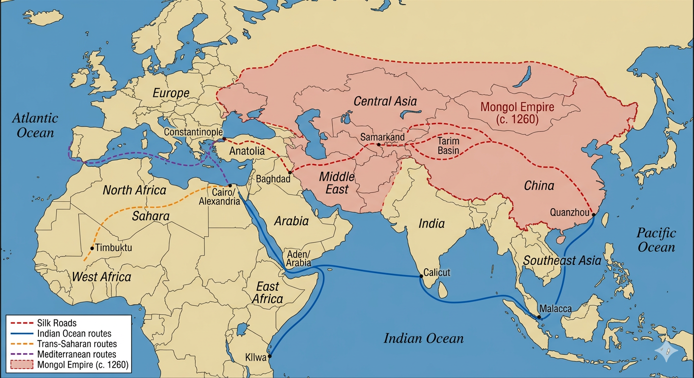
The shaded region indicates the approximate peak territorial extent of the Mongol Empire, c. 1260. Dashed lines indicate overland routes; solid lines indicate maritime routes.
Questions & Explanations
Question 1. Based on Figure 1, which of the following best describes the relationship between the Mongol Empire and Afro-Eurasian trade routes?
- A) The Mongol Empire blocked the overland Silk Roads, forcing all merchants to use Indian Ocean maritime routes
- B) The Mongol Empire's territory encompassed much of the overland Silk Road network, giving it potential control over long-distance trade between East Asia and the Middle East ✓
- C) The Mongol Empire's territory was entirely separate from the trade routes shown, lying far north of every overland caravan corridor in the figure
- D) The Indian Ocean routes passed through the heart of Mongol territory and were under direct Mongol administration
Explanation: B is correct. The map clearly shows the Mongol Empire shading overlapping extensively with the red dashed Silk Road running through Central Asia and the Tarim Basin toward China. The Mongol khanates thus controlled much of the overland trade corridor, which explains why historians credit the "Pax Mongolica", the relative peace imposed across the empire, with facilitating a surge in Silk Road commerce in the 13th and 14th centuries. A is wrong, the map shows the Silk Roads running through Mongol territory, not blocked by it; the Mongols generally facilitated rather than halted overland trade. C is wrong, this directly contradicts the map, which shows the Mongol shading overlapping the Silk Road throughout Central Asia. D is wrong, the Indian Ocean routes (blue solid line) run through maritime space clearly south of the Mongol Empire's land territory and were operated by Arab, Indian, and Malay merchants, not the Mongols.
Question 2. A historian using Figure 1 should recognize that this type of map is most limited because it
- A) shows trade routes but cannot convey what specific goods were exchanged, the volume of trade, or how the intensity of routes shifted over time within the period ✓
- B) was created by Mongol cartographers and therefore exaggerates the size of the Mongol Empire
- C) shows only European trade routes and excludes Asian and African networks
- D) excludes maritime routes entirely and shows only overland connections, omitting the Indian Ocean and Red Sea lanes that carried most bulk goods in the period throughout the era it depicts
Explanation: A is correct. Maps of trade routes are excellent for showing geographic extent and connectivity, but they have inherent limitations: they cannot show the volume of goods moving along different routes, the specific commodities exchanged at different nodes, or how the intensity of trade shifted over time within a period. A route appearing on the map tells us it existed, not whether it was heavily or lightly traveled, or more active in 1200 versus 1350. B is wrong; this is a modern scholarly reconstruction, not a Mongol document; there is no reason to assume deliberate distortion. C is wrong, the map prominently shows Asian and African networks including the Indian Ocean and Trans-Saharan routes. D is wrong, the map clearly shows both overland routes (dashed lines) and maritime routes (the solid blue Indian Ocean line).
Question 3. The trading cities shown on the map, Constantinople, Baghdad, Samarkand, Calicut, Kilwa, grew in importance primarily because of which broader development?
- A) All were capitals of powerful empires that collected tribute from surrounding regions through military force
- B) Improvements in transportation technology and commercial practices increased long-distance trade, creating demand for exchange nodes where goods could be redistributed across networks ✓
- C) The spread of Islam across Afro-Eurasia created uniform commercial laws that made trade between distant cities easier
- D) European demand for Asian luxury goods was the single largest driver of growth at all the cities shown, with merchants in Lisbon dictating which inland markets prospered across the entire Afro-Eurasian trading world
Explanation: B is correct. Improved commercial practices, caravanserai, bills of exchange, paper money, and transportation innovations, better ship designs, camel saddles, knowledge of monsoon winds, drove the expansion of trade networks. Trading cities grew because they served as exchange nodes where goods from different regions met, merchants settled, and commercial services developed. Calicut and Kilwa, for instance, were not imperial capitals but commercial cities whose importance was entirely commercial. A is wrong; Calicut and Kilwa were primarily merchant cities, not military tribute states; their wealth derived from commerce. C is wrong; Islam facilitated trust networks among Muslim merchants but did not create a single commercial law across Afro-Eurasia; Hindu, Buddhist, and Chinese merchants also thrived in these networks. D is wrong; European participation in these networks was minimal in the 1200–1350 period; Arab, Persian, Indian, Chinese, and East African merchants dominated.
Question 4. Based on the map, which of the following best explains why the Indian Ocean maritime routes and the overland Silk Roads both remained active rather than one replacing the other?
- A) The two routes connected different regions and served different commercial needs, making them complementary rather than competitive ✓
- B) Maritime technology was too unreliable in this period for sea routes to compete effectively with overland caravans
- C) The Mongol Empire monopolized overland routes and charged prohibitive tolls, so most merchants preferred the Indian Ocean route for nearly all long-distance trade
- D) European merchants controlled the Indian Ocean and restricted non-European access to the Silk Roads in this period
Explanation: A is correct. The overland Silk Roads connected inland Central Asian and East Asian markets and were suited to high-value, low-bulk goods like silk, spices, and gems. The Indian Ocean routes connected coastal regions; East Africa, Arabia, South Asia, Southeast Asia, and could carry heavier, bulkier cargo. As the map shows, the routes served geographically distinct regions and merchant communities, making them complementary rather than competing. B is wrong, Indian Ocean maritime technology including the dhow, compass, and monsoon knowledge was highly effective; the network was extensive and well-developed. C is wrong, the Mongols generally encouraged and protected Silk Road commerce during the Pax Mongolica rather than extracting prohibitive tolls. D is wrong; European merchants had minimal presence in the Indian Ocean in this period; Arab, Persian, Indian, Malay, and Chinese merchants dominated both networks.
Question 5. Which development after 1450 most directly altered the balance between the trade routes shown in Figure 1?
- A) The Black Death of the 1340s, which killed so many Silk Road merchants that overland trade collapsed and was left permanently abandoned for the rest of the period shown
- B) European development of transoceanic sailing routes around Africa that allowed direct sea access to Asian markets, bypassing both the overland Silk Roads and existing Indian Ocean intermediaries ✓
- C) The Ottoman Empire's control of Constantinople after 1453 permanently closed all east-west trade by blocking the Silk Road at its western terminus
- D) The Ming Dynasty's sponsorship of Zheng He's voyages established Chinese dominance over Indian Ocean trade and effectively ended Arab and Indian merchant activity
Explanation: B is correct. The Portuguese rounding of Africa's Cape of Good Hope (1488) and Vasco da Gama's voyage to India (1498) introduced an Atlantic-Indian Ocean route that allowed European merchants to reach Asian markets directly by sea, without passing through Arab, Persian, or Central Asian intermediaries who dominated the routes shown on the map. This eventually shifted commercial dominance away from the overland Silk Roads and reshaped Indian Ocean commerce. A is wrong, the Black Death caused significant disruption in the 1340s but occurred before 1450; trade recovered and the Silk Roads remained active well into the 16th century. C is wrong; this is a common misconception. The Ottomans did control Constantinople after 1453 and this affected European access, but it did not "permanently close all east-west trade"; the Silk Roads continued to function under Ottoman administration. D is wrong; Zheng He's voyages ended in 1433 and did not establish Chinese dominance over Indian Ocean trade; Arab, Indian, and Malay merchants continued to thrive, and the Ming subsequently restricted maritime activity.